


The pace of innovation is continuing to ramp up in the AEC Technology industry, as evidenced by this annual collection of updates, which go all the way from design to construction, not just of buildings but of larger neighborhoods as well as infrastructure. There are updates related to BIM from Ideate, Xinaps, and IMSI Design; developments in laser scanning from Paracosm and Pointfuse; preconstruction and construction updates from Join and Autodesk; a move to apply sustainability principles to larger communities in addition to individual buildings from IES; the start of integrating GIS with BIM from ArcGIS; and the expansion of Transoft’s transportation engineering portfolio with a key acquisition, Keysoft. There is also a simple but important productivity tool launched by 28Hands, a spin-off from Arup.
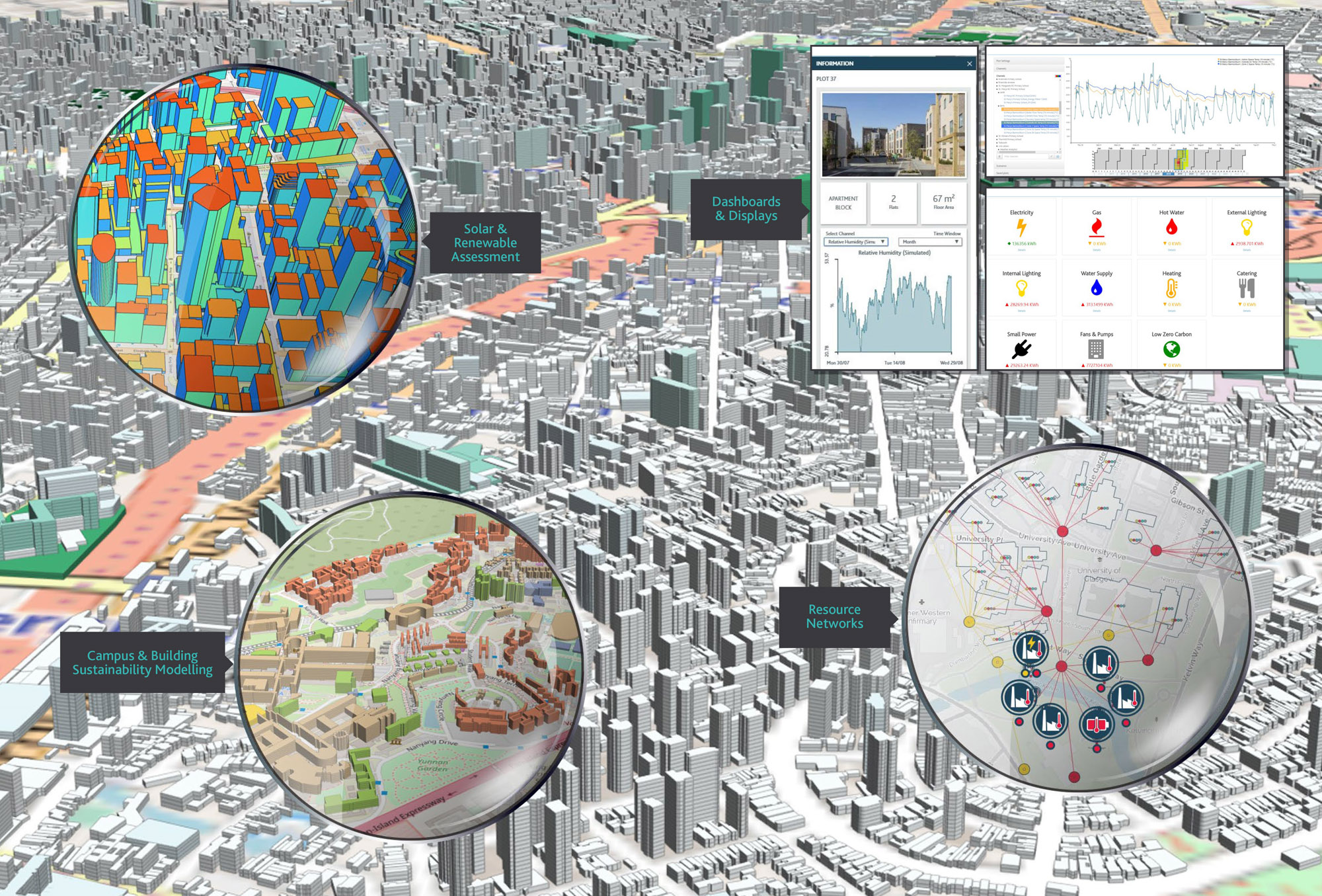
The ICL is a brand-new technology platform for developing sustainable communities that was launched by the leading performance analysis solutions vendor, IES, earlier this year. Up until now, IES solutions such as IESVE have been primarily focused on individual buildings, but with ICL, the company is scaling up its expertise to larger groups of buildings such as campuses, neighbourhoods, and other communities. Envisioned as digital twin technology for the built environment that is focused on energy efficiency and sustainability, the ICL makes it possible to create dynamic 3D models of any community or group of buildings that reflect real life performance, simulate their lifecycle, and help better plan sustainable solutions for them now and into the future.
The solution comprises a platform of interconnected decision support tools that can analyse the energy performance of multiple buildings, address their simultaneous operational performance and the energy systems supporting them, and assess the impact of community-wide solutions such as district heating and cooling, and renewables such as photovoltaics, to improve efficiency, reduce cost, conserve resources, and reduce carbon emissions (Figure 1). Users can bring any data from any source—such as IoT data, sensor readings, etc.—into its integrated platform to investigate built environment performance at any level, fill in gaps with simulated data, link each source to the related urban feature and create dashboards to communicate and drive engagement. They can hone in on problem areas, identify patterns, improve performance, explore “what if” scenarios. and plan for the future. The shared central database and interconnected tools allow the data and analysis results to be shared across the platform.
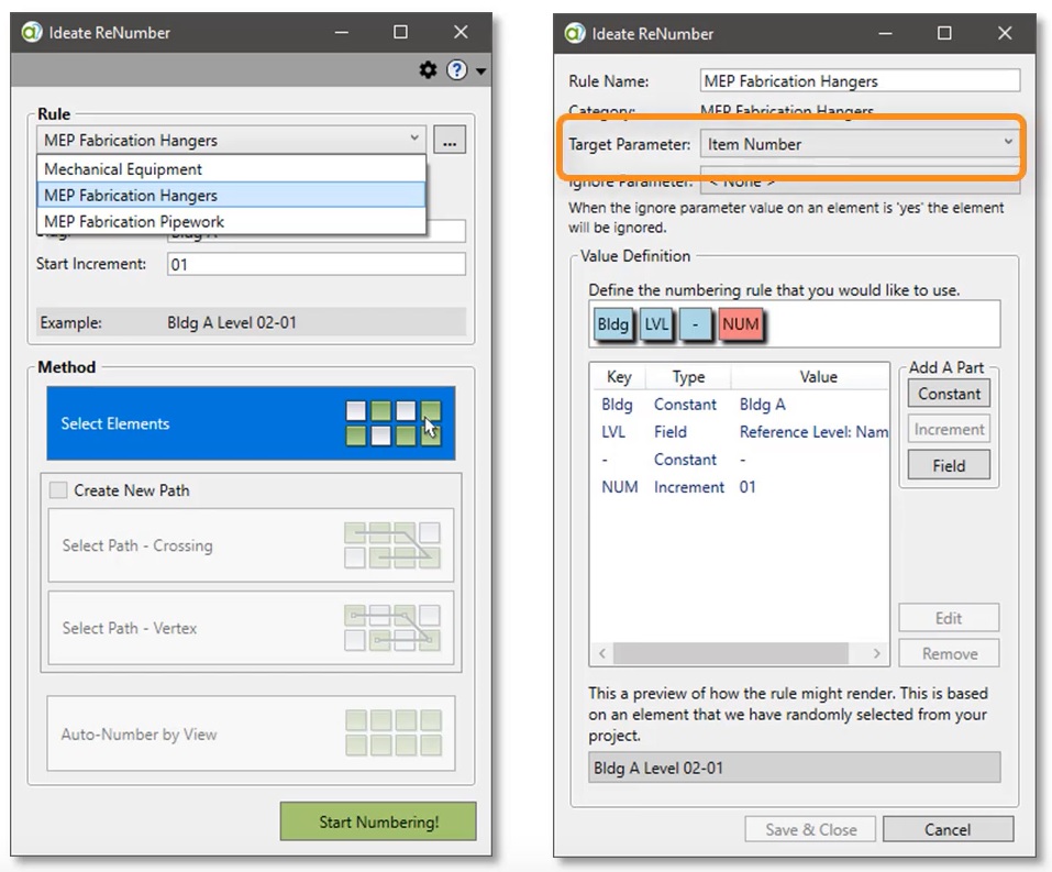
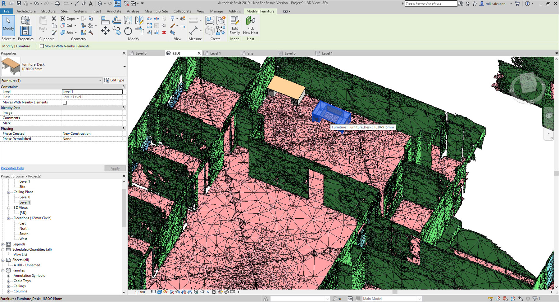
Ideate, one of the leading Autodesk consultants, develops a range of plugin tools for Revit for better data management and a more efficient workflow. While many of these have been around for some time—see an overview of Ideate Explorer, Ideate BIMLink, and Ideate Sticky in the article, “Technology Solutions for AEC Exhibited at Autodesk University 2015”—Ideate also has a suite of tools called IdeateApps that is more recent. This is a set of Revit applications designed to increase the productivity of the entire project team and simplify the tasks that Revit users perform every day, such as creating views, spell checking, aligning, cloning, managing sheets, renumbering, smart deletion, and quick selection. These tools are continuously improved and updated to correspond to the latest version of Revit and are based upon user requests and input.
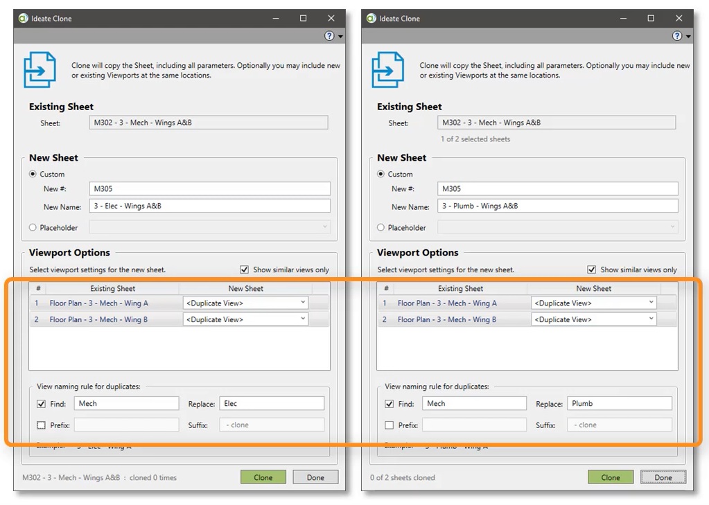
The latest IdeateApps update that was released in May includes support for Revit 2020 and several new enhancements, including supporting rules for MEP fabrication parts in Ideate ReNumber (Figure 2), expanding keynote tags by subdividing the category into the three keynote types in Ideate QuickSelect, support of structural connections and the new Path of Travel feature also in Ideate QuickSelect, and improved naming control in addition to the ability to clone multiple sheets in the same operation in Ideate Clone (Figure 3).
Ideate also has a new tool, Ideate StyleManager, that can be used to analyze, delete or merge non-standard Revit styles that are automatically brought into the Revit model when outside content is loaded or imported into it.
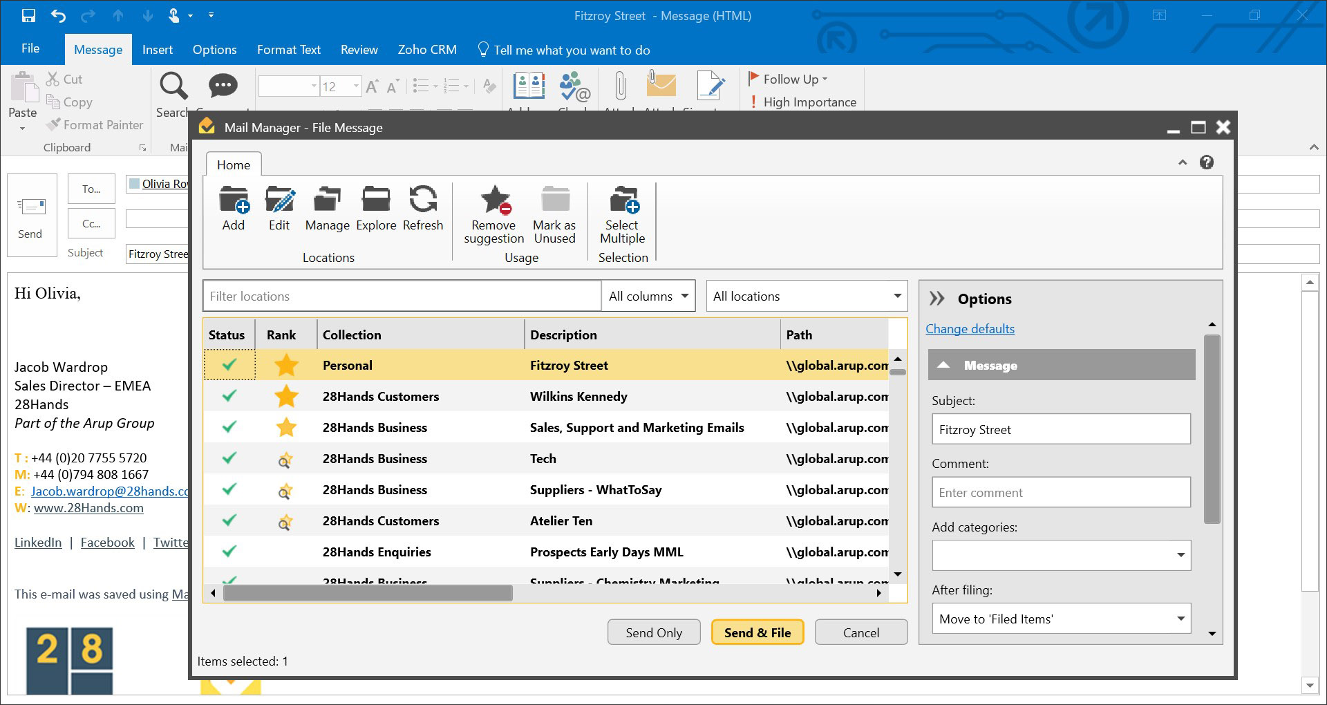
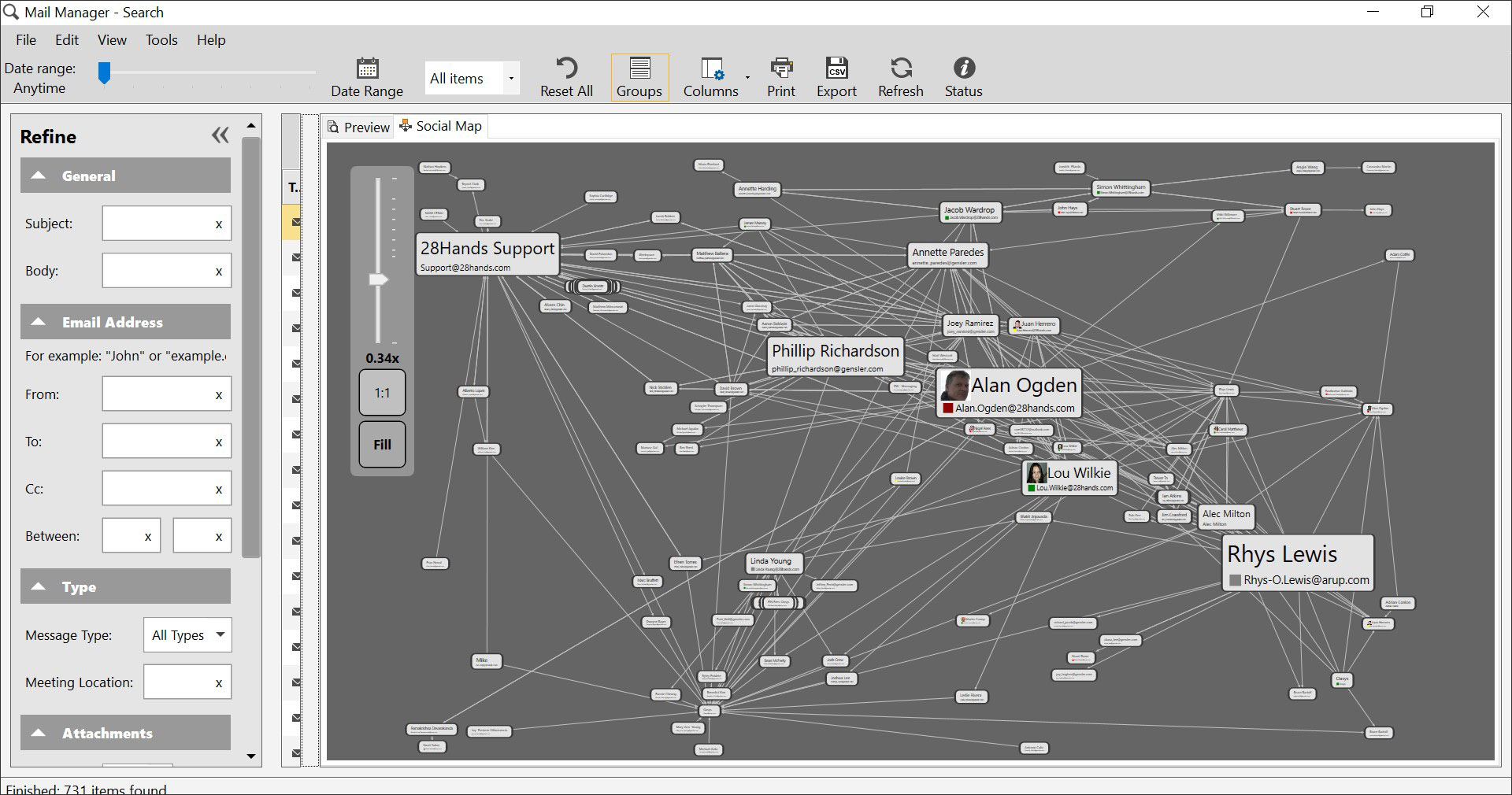
The intriguingly named “28Hands” vendor is a spin-off from the leading structural engineering firm, Arup, to commercially market an email management solution that had initially been developed internally to streamline the storage, search, and retrieval of the increasing amount of email associated with a project. As with the email management solutions of other PIM (project information management) solutions such as Newforma Project Center, Deltek PIM, and TonicDM, 28Hands Mail Manager primarily works as an add-in to Microsoft Outlook. The emails can be filed on a local disk, network server, or cloud storage, thereby becoming an important part of the project documentation and collaborative process. The application can be set up to prompt users to file sent and received emails and in time, it learns, using an AI-engine, to predict where an email should be filed, allowing users file emails correctly without thinking about it (Figure 4). Mail Manager integrates with popular cloud storage and construction management applications including Box, OneDrive, Dropbox, SharePoint, Symantec, Viewpoint, and ProjectWise.
An interesting feature of the application is the ability to present a visual representation of a user’s email traffic on a project or based on a certain search, as shown in Figure 5. This social map shows the names and email addresses of selected contacts in boxes, with the size of the boxes indicating the number of emails sent to and from that contact.
(By the way, the name of the company, I found out, comes from the number of people who were there at the beginning—14 people forming 28Hands!)
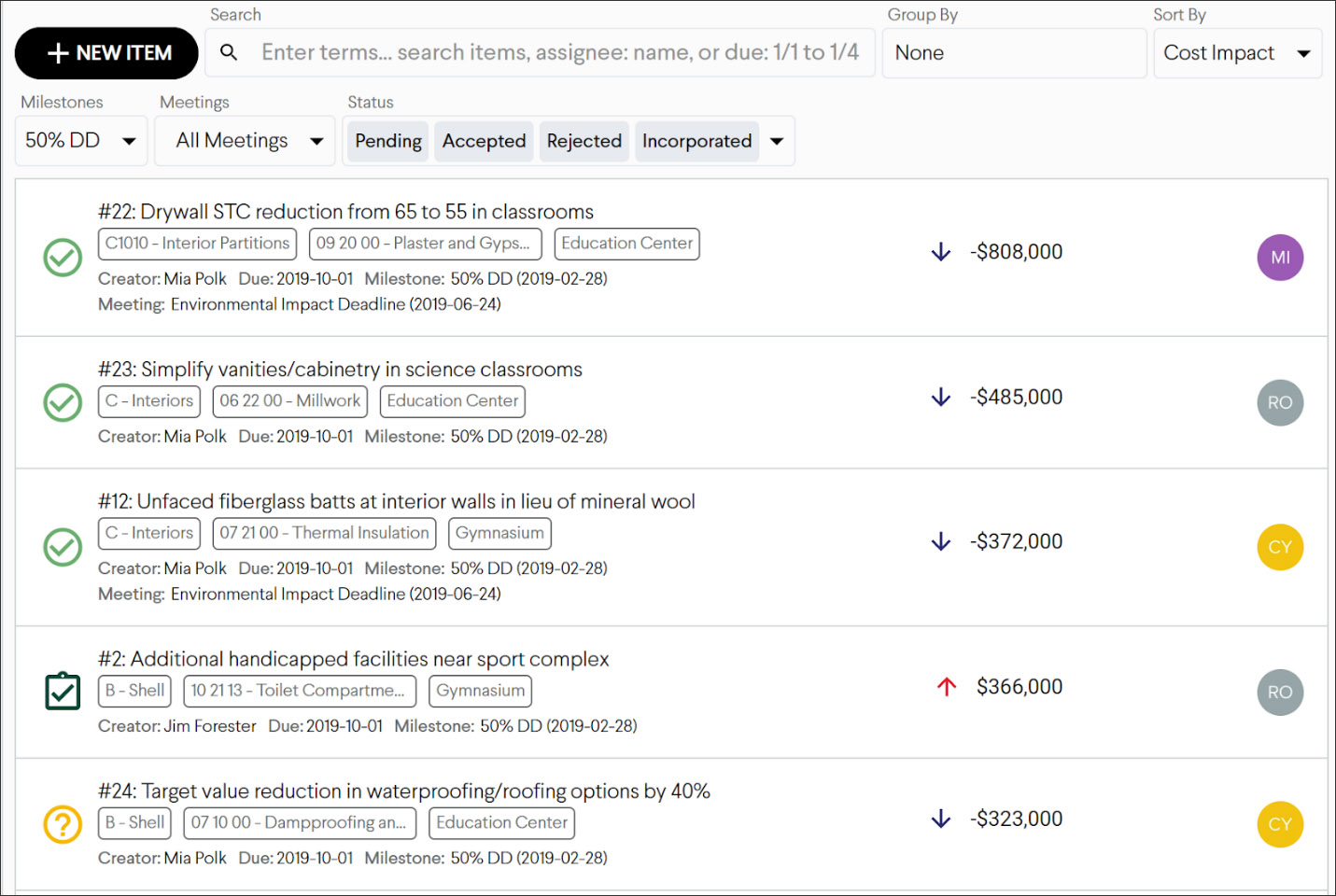
Join is a new venture focused on preconstruction intelligence. More specifically, it provides a platform for collaborative decision-making for early project phases that can critically influence the success of the project. This platform, which is cloud-based, allows multiple stakeholders to share information around constructability, value analysis, and risks and opportunities, all of which are available in real-time to the entire project team. Its project dashboards include trend lines that automatically calculate and present how the project is tracking towards the target budget at any point in a project. Graphs also show how items under consideration for the current milestone estimate impact work breakdown structures, stakeholders, or any other category based on project or owner preferences (Figure 6). The current status of items under consideration shows what’s still under consideration, or has been rejected, approved, or incorporated into the estimate. Collectively, these graphs provide all project team members visually concise, presentation-quality metrics on the current project status.
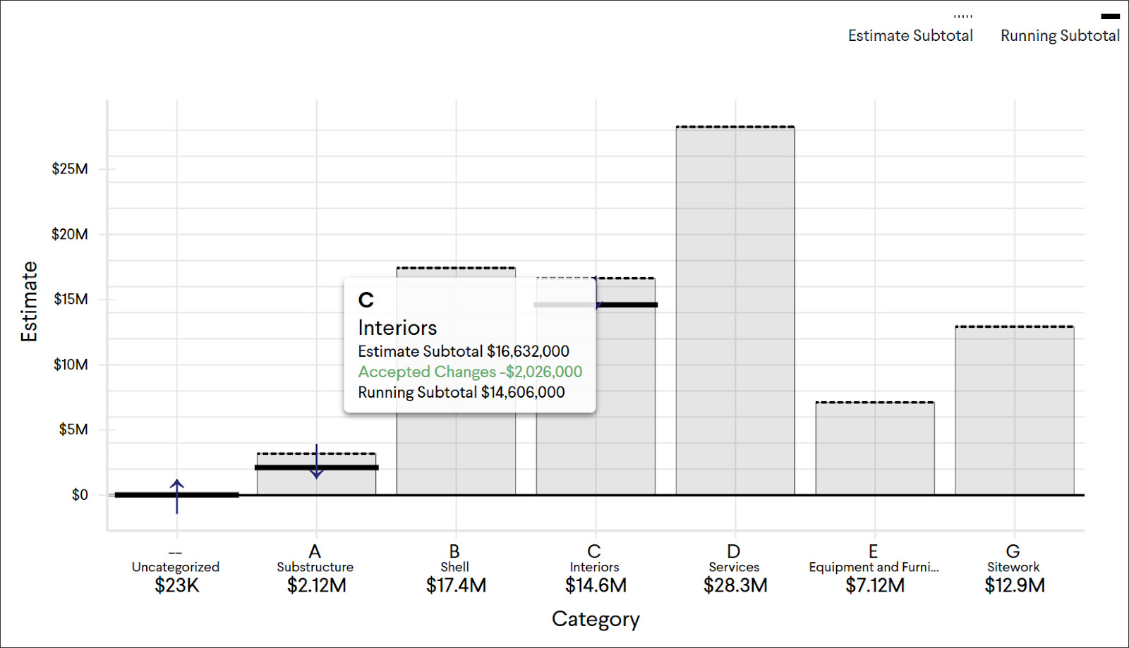
Milestone data comes from multiple sources, including the high-level estimate data from the contractor, the design team’s document sets, building models, and specifications, and the owner’s requirements such as target budgets and preferences. The team collaboratively generates items for consideration that can range from constructability challenges, design alternatives, value engineering, and more (Figure 7). Each item can have detailed cost breakdowns, assignee, due date, classification by MasterFormat, Uniformat or custom category, supporting documentation to help make a decision, and permanent records of all the changes and decisions made.
By transparently capturing all the key decisions made between designers, owners, contractors, and suppliers at the preconstruction phase in this manner, the team can work more efficiently towards the project budget and schedule goals. Contractors can spend less time coordinating information across spreadsheets and presentations; designers can be more actively engaged in the ideation process and get a better understanding of cost implications; and owners can easily find any information related to how the project is tracking toward its schedule and budget goals.
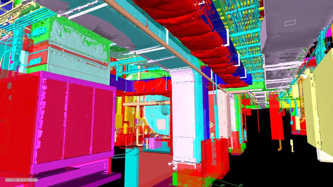
Paracosm develops a handheld laser scanner and associated software that can process the point clouds it captures. The scanner, PX-80, is Paracosm’s flagship solution and it is optimized for fast and accurate documentation of indoor and outdoor spaces. The 3D data produced by PX-80 can be used in the AEC industry for a wide variety of applications like generating accurate floor plans or as-built CAD models for an asset, capturing the topology of a site, conducting regular progress reports on construction projects, and so on. The device comes with a 360° color camera, a lidar sensor (of the kind found in autonomous vehicles), and a survey-grade inertial measurement unit (IMU). It is controlled by an attached iPad (Figure 8).

What makes Paracosm’s device unique is that it is powered by Paracosm’s proprietary SLAM (simultaneous localization and mapping) algorithm, which reads data from its camera, lidar sensor, and IMU to track the scanner’s path as you walk it through a space, and uses this data to correctly position the 3D points at the end of the scan. The technology allows for more accurate 3D capture, even in poor lighting conditions and areas without distinct geometric features like long hallways. Also, it is fast, enabling surveys can be performed by a single person in as much time as it takes to walk through a site, allowing projects to be scanned as often as desired, even daily.
Before the development of SLAM technologies for 3D mapping, mobile-mapping systems relied on GPS for the location information they needed to correctly position the points at the end of the scan. Since this made them impossible to use indoors where GPS signals didn’t reach, users were often restricted to using tripod-based 3D scanners, which are slower and usually more expensive.
Paracosm’s PX-80 comes bundled with all the software applications a user needs to generate a 3D model, including Capture, an iOS scanning app that operates the scanner and provides real-time visual scan feedback, and Retrace, a viewer for the 3D point clouds and panoramic imagery captured by the PX-80 that loads quickly and allows the scans to be seen in multiple different views (Figure 9). Since the PX-80’s 360° color camera can capture high resolution spherical imagery, the steps of the scan path can literally be retraced, similar to Google Maps’ “street-view” style.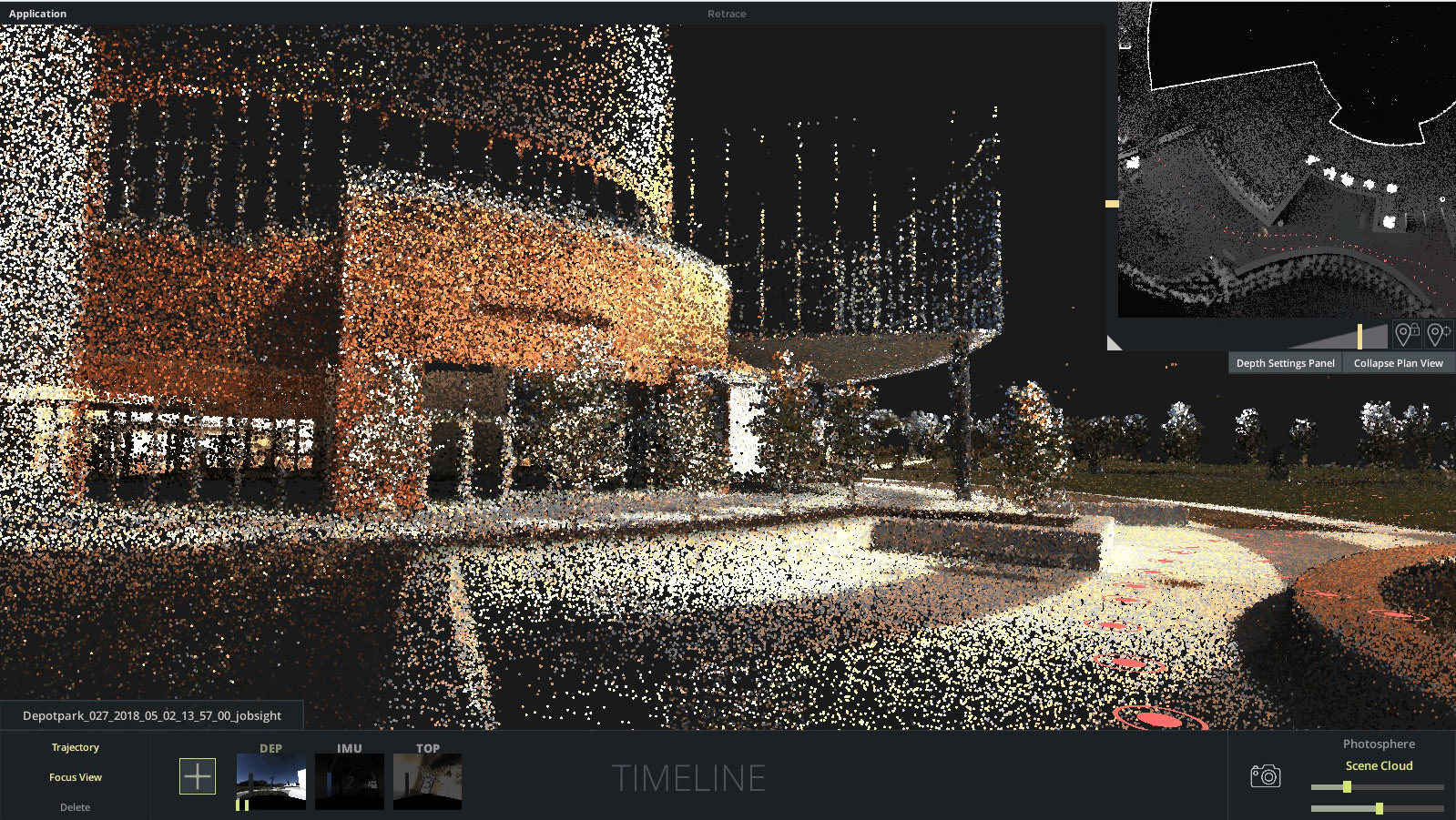
This is another application in the area of laser scanning, a relatively new software that has been 5 years in the making. One of the main issues with laser scans is that the point clouds they create typically comprise a huge dataset of points—often in the billions—and to be able to convert them into accurate and usable 3D models can takes days of work and a great deal of manual intervention. Pointfuse addresses this problem by automating it. It has a powerful modeling engine that automatically converts point cloud datasets into accurate 3D mesh models with distinct components that can be individually manipulated (Figure 10).
Pointfuse also significantly reduces the file size of these 3D models—by as much as 90%—by reducing the data density within each surface whilst maintaining the fidelity of the model. This makes ongoing use of the models easier, faster and more efficient, including being able to share them on online 3D collaboration platforms, such as BIM 360, 3D Repo, Revitzo, and Trimble Connect.
The latest version of Pointfuse that was released a couple of weeks ago now includes a new streamlined workflow which makes object classification easier, using templates and shortcuts to ensure maximum efficiency. This ability to classify objects within Pointfuse greatly impacts how as-built data is utilized within digital design workflows—being able to quickly compare specific as-built objects with the design enables more accurate clash detection, reducing the number of false clashes being flagged. Additionally, the availability of IFC templates that can be created and edited for specific AEC applications allows selected objects to be classified and mapped to ensure compatibility with accompanying multi-disciplinary workflows for design and construction (Figure 11).
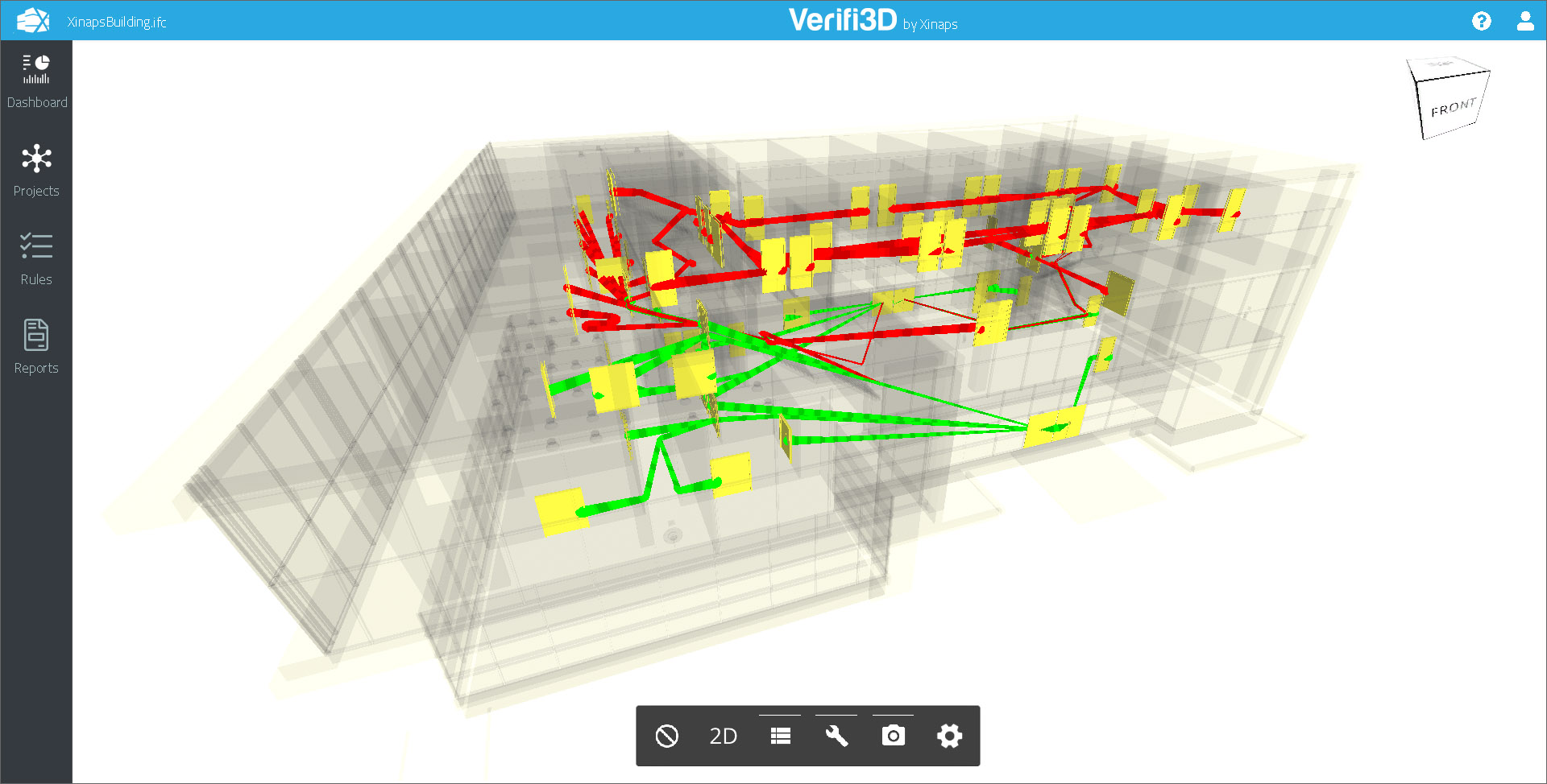
Verifi3D is a new cloud-based data validation tool that will be launched next month by Xinaps, which has, until now, been best known for its suite of Revit plug-ins. With support for both Revit and IFC files, the new product allows users to classify their building model data, visualize it in 3D and 2D, perform customizable checks and validations, and report issues. It allows different types of checks such as clash detection, and egress path and parameter checks (Figure 12). It also allows users to check their building models against local rules and regulations by creating their own rule sets, which can be saved and reused. For issue tracking, the solution uses the established BCF format, and it is integrated with collaboration platforms, such as Autodesk BIM 360.
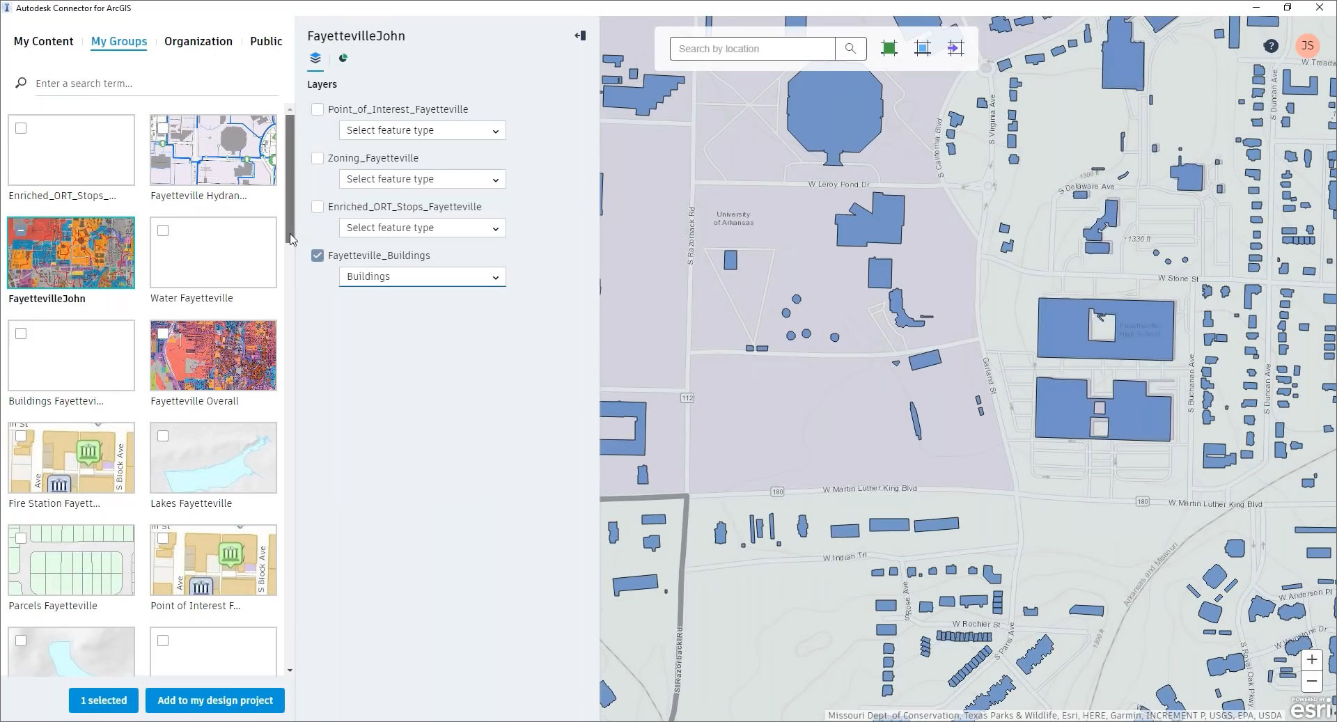
Esri is a leading developer of GIS solutions, and ArcGIS is its flagship GIS product suite which now works online and on mobile devices in addition to desktop computers and servers. While there a whole slew of industries that need GIS, for the AEC industry in particular, GIS really comes into play in the design of infrastructure. Relatively new infrastructure design applications like Autodesk InfraWorks have emerged with advanced modeling capabilities, further enhanced by integration with ArcGIS. In fact, Esri is now introducing dedicated ArcGIS AEC Collections for AEC firms that connect ArcGIS to both InfraWorks as well as Revit, allowing engineers and designers to access GIS data from within the Autodesk applications they use (Figure 13). This allows buildings and infrastructure to not only be visualized within their environmental context but also allows for the use of GIS data for analysis and evaluation of the design for improving its quality and fit.
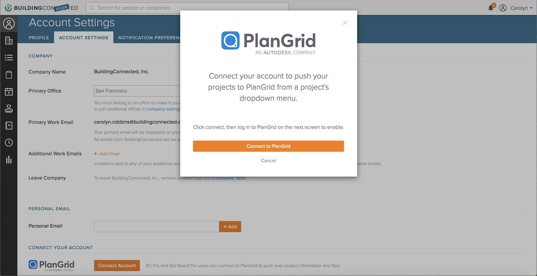
In addition to the updates profiled above, there were some more updates from other vendors. Autodesk announced an integration between BuildingConnected, the platform for bid management, risk analysis and other preconstruction tools that it acquired at the end of last year, with PlanGrid, the construction management and collaboration software it also acquired late last year. The integration will allow BuildingConnected users to automatically push design, estimation and other critical preconstruction data to PlanGrid, eliminating manual project creation. In addition to saving time, reducing cost, and minimizing errors, it should also enable Autodesk’s construction customers to better connect workflows between the design and preconstruction process in the office with site construction in the field.
On the design front, there was a new release of TurboCAD from IMSI Design. While TurboCAD is still very much a CAD application, it does have some BIM capability with IFC support, a BIM palette, and tools for creating building objects such as walls, doors, windows, roof, stairs, etc. In the new 2019 version of TurboCAD, the data collection of IFC files has been improved, the BIM Palette now shows the BIM file structure, and the BIM tool and BIM Palette’s UI’s are more tightly integrated, making the architectural modeling parts of TurboCAD easier to use (Figure 15).
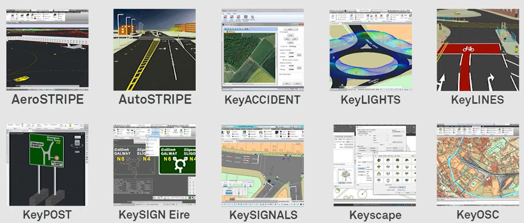
And finally, on the infrastructure front, Transoft Solutions, the leading vendor of transportation engineering design and analysis software, acquired Keysoft Solutions, which develops BIM tools for highway design, traffic management, and landscape planning and design. The acquisition expands Transoft’s extensive portfolio of tools for aviation, civil infrastructure, and transportation professionals with the addition of Keysoft’s specialized tools that can assist engineers and designers with road safety, road layout, sign design and installation and highway maintenance (Figure 16).
While it is always interesting to collate this annual mid-year roundup of AEC Technology updates—the continued development of new solutions, in particular, is always very encouraging and bodes well for the AEC industry—there were some noteworthy trends that emerged in this year’s roundup, including the growing momentum in laser scanning, the convergence of GIS with BIM, the expansion of transportation engineering solutions, and the increase in the number of model-checking solutions. At the same time, it was evident that everyday productivity remains important with plugins that simplify the process of working with BIM applications. There is also room for point solutions, which explains why a dedicated email management solution is a viable product even with several PIM solutions offering this capability. It was interesting to see a brand-new solution for preconstruction, which is not an area that has seen much development so far.
And finally, it was heartening to finally see sustainability move from individual buildings to larger neighborhoods. Hopefully, this is just the start, and we will eventually have tools for “smart cities” that makes sustainability a key component of their smarts.
Lachmi Khemlani is founder and editor of AECbytes. She has a Ph.D. in Architecture from UC Berkeley, specializing in intelligent building modeling, and consults and writes on AEC technology.
Have comments or feedback on this article? Visit its AECbytes blog posting to share them with other readers or see what others have to say.
AECbytes content should not be reproduced on any other website, blog, print publication, or newsletter without permission.