


The construction and reconstruction of industrial enterprises have become complex and resource-intensive processes, requiring highly accurate initial data and a substantial volume of project information. The efficiency and success of production directly depend on the quality of design, and design, in turn, depends on the quality and comprehensiveness of surveying works. The need to transition to digital methods of surveys, design, and construction using information models is evident. Since the majority of construction sites are located on the premises of existing industrial facilities, characterized by a vast number of production buildings, transit communications, and engineering structures, there is a necessity to carry out work not only concerning planned construction projects but also in alignment with existing facilities and technological processes at these enterprises.
In this article, we will discuss the approach to conducting geodetic surveys on the premises of operating industrial enterprises using modern instruments and technologies.
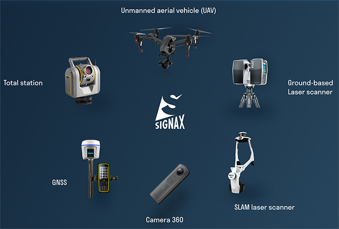
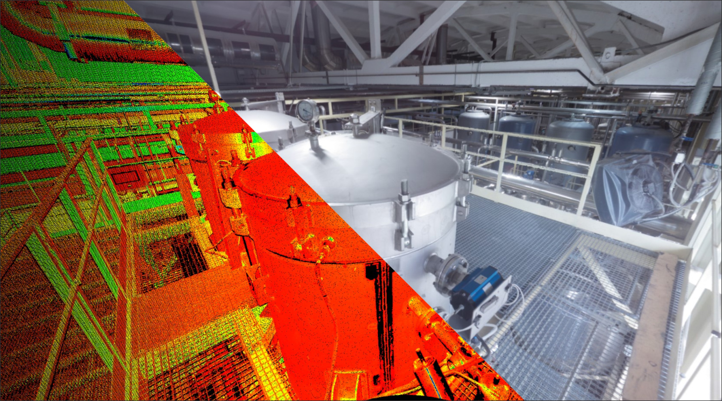
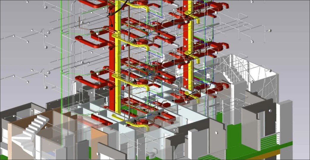
In recent years, in the sphere of geodetic surveys and widely used total stations and satellite equipment (GNSS), unmanned aerial vehicles (UAVs, also known as drones, quadcopters, etc.) and laser scanners have been actively employed. These tools significantly enhance the accuracy and comprehensiveness of collected data for industrial facility design, construction, and reconstruction (Figure 1).
We will not describe the technology of regular surveying work, but we will highlight essential features that can complement their implementation with laser scanners and UAVs.
The first aspect to consider when conducting such work is the base of control points, which enables the representation of the object within a unified coordinate system, aligning diverse survey results in a coherent space without distortions. The base should be established regarding the existing surveying base in the region and should consider any pre-existing surveying control points at the facility. Subsequently, utilizing these benchmarks, the construction and operation of the facility will be carried out.
The main stages of conducting digital aerial surveys and laser scanning are listed below:
The list of instruments used during the execution of the surveying tasks are:
After the completion of the survey, the squad (surveyors, designers, client, contractors, etc.) receives the following additional set of survey materials:
The application of UAVs and laser scanners in the reconstruction of industrial facilities offers several advantages (Figure 4). Firstly, these technologies significantly accelerate the process of geodetic surveys and the creation of precise three-dimensional object models. They enable the collection of comprehensive and complete data quickly, saving time and resources. Secondly, UAVs and laser scanners provide high measurement accuracy, helping to avoid gross errors and minimizing the impact of human errors. Thirdly, using automated spatial information collection systems reduces employee risks, as UAVs and laser scanners can carry out surveys in hazardous areas and elevated locations without the direct presence of surveyors in the immediate danger zone.
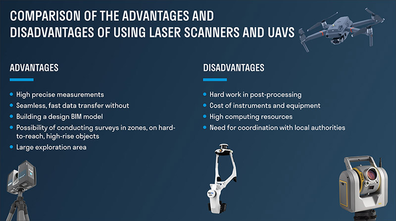
It's important to note that many of the disadvantages (listed in Figure 4) are largely surmountable. For instance, the equipment cost will likely decrease over time due to increased production volume and optimization. The labor-intensive nature of post-processing can be reduced by implementing more advanced field data interpretation techniques and automatic classification of acquired point clouds. The need for substantial computational power can be met by utilizing cloud platforms, allowing remote access to external computing resources. Moreover, administrative difficulties are likely to be dismantled as the necessity and effectiveness of these surveying methods become better understood and acknowledged.
UAVs are equipped with specialized cameras and sensors that can collect data about terrain, elevation, coordinates, color, shape, and the structure of objects. They can perform automated flights along predefined routes and coordinates while the acquired data is processed using specialized software.
On the other hand, laser scanners can complement aerial survey data, especially in areas with complex utility networks. They also provide highly accurate “inside” building data (Figure 5). These technologies offer a comprehensive and detailed understanding of the industrial facilities’ external and internal aspects, facilitating effective planning, design, and decision-making processes.
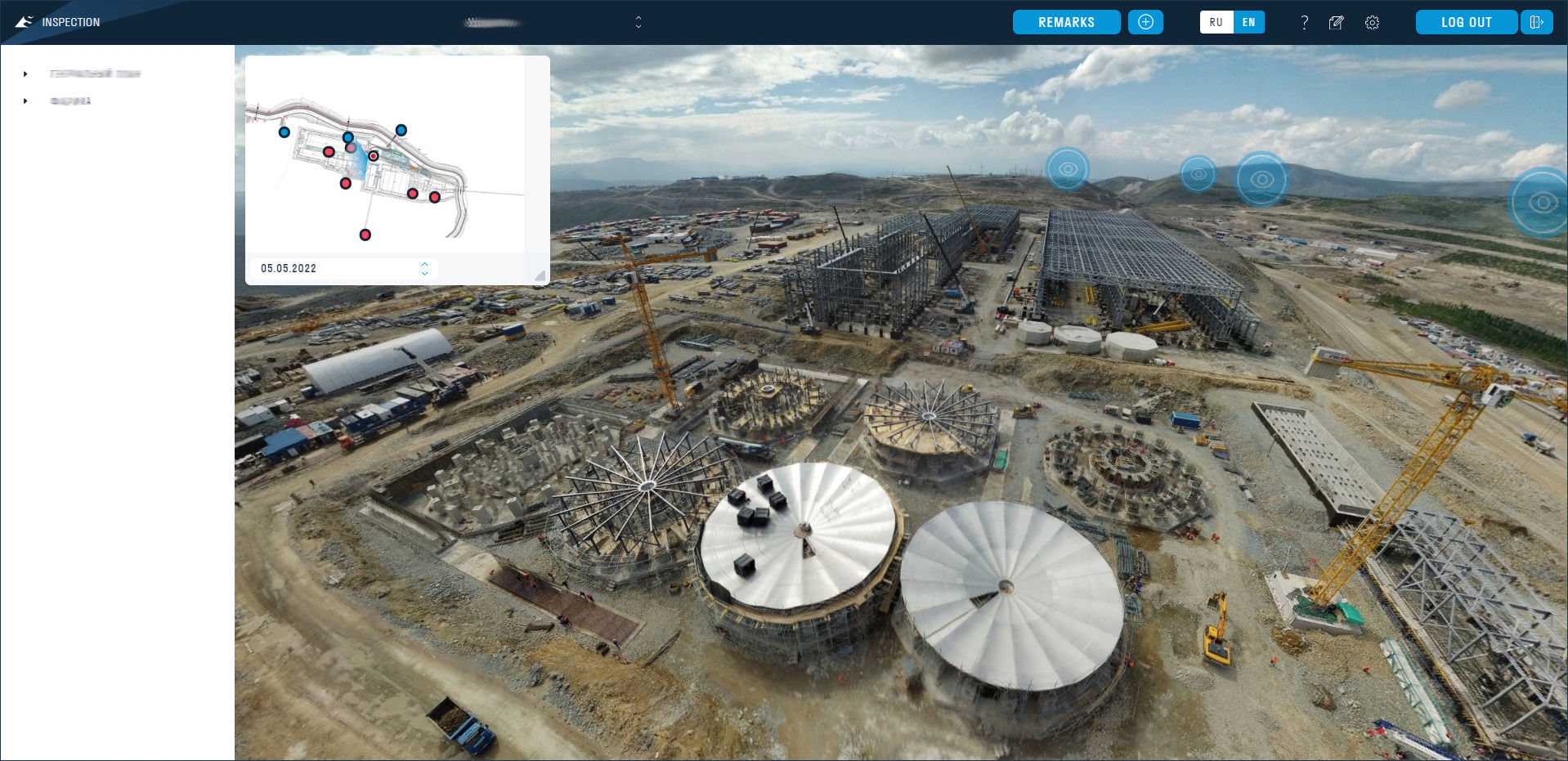
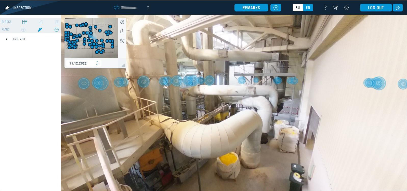
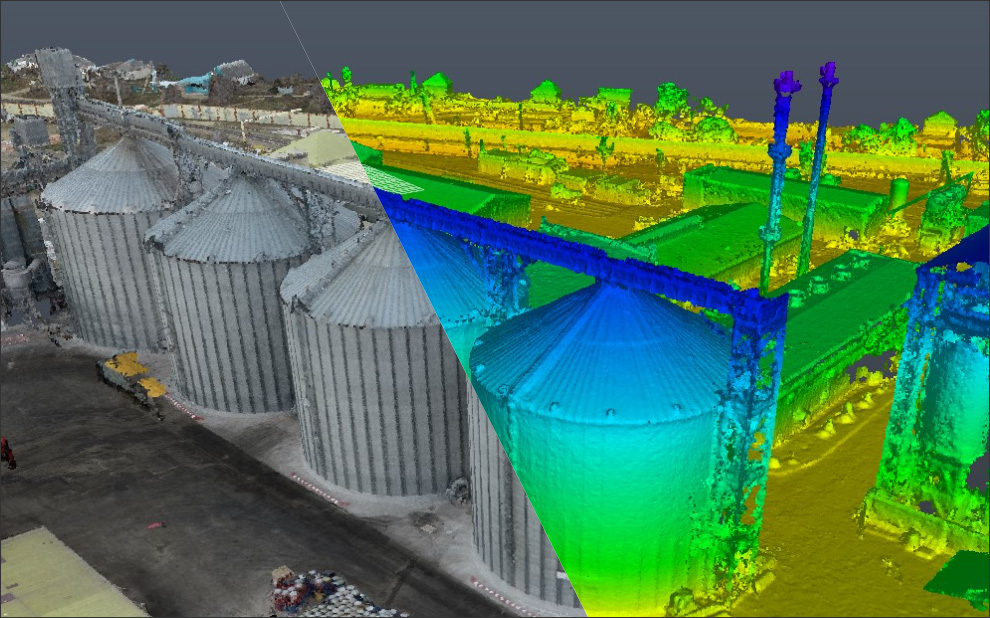
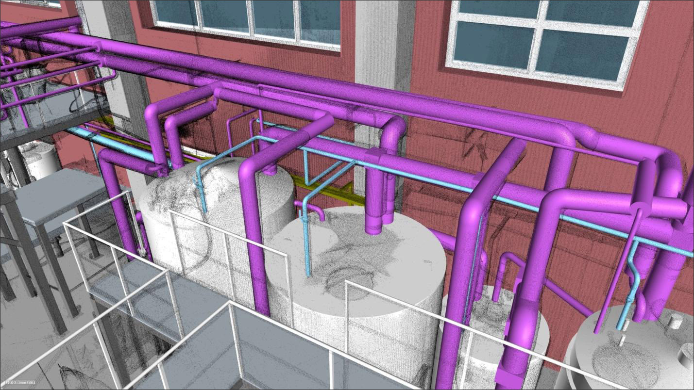
The output of this kind of surveying work encompasses not only engineering and topographic plans but also orthophotomosaics (Figure 6), elevation maps, panoramic tours, and point clouds of surveyed objects (Figure 7). The data gathered from UAVs and laser scanners enable the swift and highly accurate creation of information models (Figure 8) for the terrain and industrial facilities. These models, in turn, aid in precise project design and cost estimation, providing accuracy paramount for successful project execution.
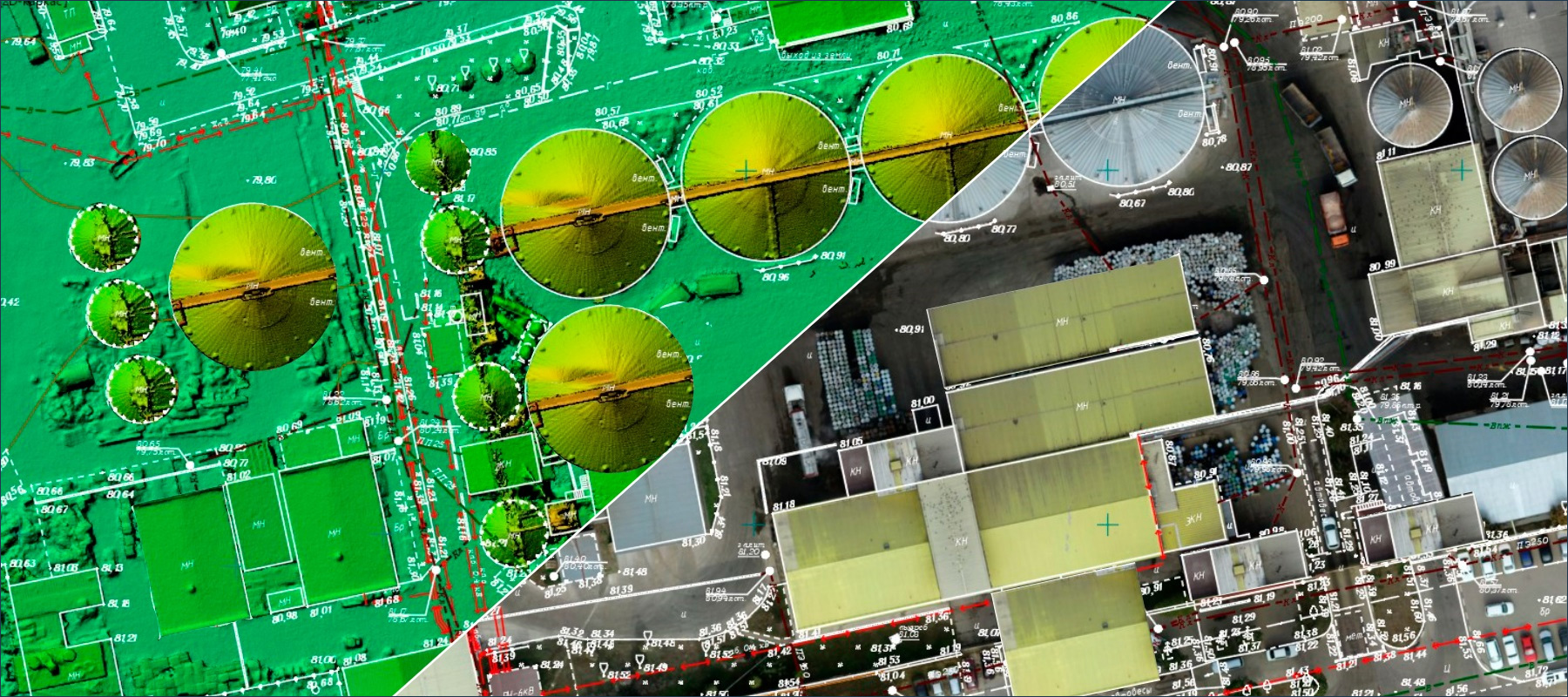
It's worth noting that, as of today, the predominant outcome of geodetic surveys is usually a topographic plan, which depicts the situation, terrain, and positions (coordinates) of buildings and structures. A distinct feature of such a plan is that it is created using conventional symbols, representing qualitative and quantitative characteristics of the surveyed area in a flat representation (orthogonal projection). Subsequent design and construction are based on these results, which depend on the subjective choices of the surveyor regarding the symbols used and the method of summarizing information.
However, with the integration of UAVs and laser scanners, the scope of surveying has expanded to include a more detailed and accurate representation of the environment and facilities. This transition allows for a more comprehensive understanding of the site, better decision-making, and improved project outcomes.
Point clouds, in particular, constitute a three-dimensional model composed of numerous points, each with its coordinates and attributes. Point clouds provide a significantly more detailed description of objects and their characteristics in space, and they can include additional information such as color, temperature, and multispectral data (Figure 7). It's evident that not all construction participants require such a level of detail or volume of data, and most tasks can be accomplished using flat topographic plans. However, point clouds offer extensive possibilities and advantages for the project team.
Point clouds and orthophotomosaics provide the capability to digitally "document" the site conditions in a detailed information model (Figure 8), allowing the team to revisit the data at any point and perform necessary additional measurements if required. This level of detail and flexibility can significantly enhance decision-making and problem-solving during project planning, design, and construction phases.
In the MENA (Middle East and North Africa) region, our experience with the application of UAVs and laser scanners in construction and industrial facility reconstruction has given remarkable results. The unique challenges and opportunities presented in this region have allowed us to showcase the effectiveness and adaptability of these technologies. One key aspect of our regional experience is the utilization of UAVs and laser scanners to address the vast and diverse landscapes often encountered in construction projects. From the expansive desert terrains to urban environments, these tools have provided us with the capability to conduct geodetic surveys and construction site monitoring with unprecedented efficiency.
Furthermore, our experience has demonstrated how these advanced technologies have significantly improved construction project control and industrial facility management in the MENA region. The ability to capture detailed point clouds, create accurate orthophotomosaics, and generate precise digital terrain models has been instrumental in ensuring project timelines are met, and resources are optimized. Additionally, the speed and safety offered by UAVs and laser scanners have proven invaluable, particularly in regions where adverse weather conditions or difficult terrain can pose substantial challenges. As we continue to work in the MENA region, we are excited to witness the ongoing evolution and expansion of these technologies, further enhancing their applications and solidifying their position as indispensable tools for surveying and construction projects in this dynamic part of the world.
The application of UAVs and laser scanners in the construction and reconstruction of industrial facilities represents an efficient technology for geodetic surveys and construction site monitoring. Presently, the benefits of point clouds, orthophotomosaics, digital terrain models, and more are apparent to most professionals in surveying, construction project control, and industrial facility management.
These tools provide accuracy, speed, and safety to the surveying process. Their utilization is expected to continue evolving and finding more applications.
 Andrew Serafimin is the head of the Digital Survey department at SIGNAX. He has a diploma in Mine Surveying, over 15 years of experience working as a Mine surveyor/Geodetic Engineer, and several scientific publications in specialized journals. He has experience in civil and industrial construction projects, performing special works on monitoring deformations, creating a geodetic base, topographic plans, underground surveys, inclinometric observations, and aerial photography. He established and led the pioneering Geodetic Control Department within leader engineering company, implementing precise surveying techniques for geodetic control throughout various construction projects. More details about Andrew are at: https://www.linkedin.com/in/serafimin/
AECbytes content should not be reproduced on any other website, blog, print publication, or newsletter without permission.

ZELUS describes the Phase One renovation of the New Orleans Superdome, for which it provided pre-construction services. The Superdome was originally built in the 1970s and has become one of the most iconic sports stadiums in the US.

Robotics is still a relatively new addition to the ancient land surveying industry. This article by Jane Marsh, Editor-in-Chief of Environment.co, highlights the many benefits surveying robots bring to the industry, bringing it closer to a monumental shift.
In this article, Erik Hultgren of Tech Soft 3D, discusses the advances made in visualization within the AEC space that keep making it taking quantum leaps forward, unlocking exciting new use cases and capabilities.
Tucker Cedarleaf of Cedar+Mac shows how and why traditional laser scanning tied to survey control is the only method of 3D capture that produces baseline data of the quality and reliability required for AEC industry use.